Hillforts - A fan site
.
Sometimes you have to press enter/ return key, on your keyboard on the address bar to go to a page after you pressed on it's link.
Moel Hiraddug Hillfort, or Dyserth's hillfort, is a fort in Denbighshire north Wales, at the settlement of Dyserth, which is not far from Rhyl.
So to start with first of all, Dyserth's hillfort, Moel Hiraddug is described by some as having been decimated by quarrying in the recent past. If you look at it though, that is almost like the literal truth of the original Roman usage of the word " decimate ", as in meaning one tenth destroyed. I say this as on the bright side around two thirds still remain for safely viewing and examining, to your heart's content.
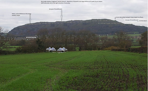
* My pictures should show a well defended by ramparts stronghold that reaches to a height of 265 metres above the nearby coast’s sea level plains and seascape. With a not completely but still relatively flat slanting to it’s east, scalp, with high bumps and contours across this limestone ridge.
* Well that headtop is surrounded by a hairline of ramparts that are 2400 feet long in total, roughly covering a area 280 by 480 foot wide, so 12 hectares, or 10 to 12 football or soccer pitches in size.
* The fort, sites the Clwydian estuary to the west, the Clwydian Valley, and Clwydian Hills to the south, slightly higher lands than river floors, to the east of farms, and the Gop and Trelawnydd, and the Halkyn hills to the north, just beyond the road between Holywell and Rhuddlan, and just before the coastal plain where Prestatyn sits.
* There are a number of denuded ramparts on the north and west, plus the remains of a rubble wall, at the rim of the east, that is visible from afar. With in the north, a gaping quarry.
*There are 3 main routes up the fort, one from Dyserth, through gorse and thicket, and one from the east across farmland, but the one I normally go up is along a more comfortable path, which heads up from the south west of the fort along from a 1 lane road, that passes between Dyserth and Cwm. I have parked in Cwm and walked to the fort from there, and walked from Dyserth along the 1 lane road, to the foot of the path where there is even a information guide board.
* There have been a number of excavations of the fort, including in the 190s, with all sorts of finds, including indications of roundhouses atop of the fort, and even ornaments. The most important find here was made in 1872, when a fabulously decorated 2nd century BC shield or casket cover plus bits of a sword blade were found here, when a road was being built for quarrying or mining. This shield was found under 3 foot of rubble of a rampart that had collapsed. I mean when you hear it was a shield under rubble it may make you wonder if it was from a battle, but the curved plates also had piercing holes, for holding it onto something. So it may have been a casket cover for a barrel or something. The shield itself is of the late Iron Age, La Tene fashion, which like so much of this pan-Western European Celtic style has a glorious whirligig pattern and streamer designs leading from that. I mean the item alone brings to life a vision of great culture and sophistication, amid the imagination inspiring enigmaticness of the fort’s defences and gates. So really for this time you can imagine that type of symbol, decorating objects of many of the characters items of the era. Bringing a individual kind of personality to the long time.
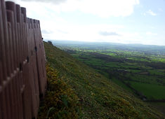
* On a clear day you can see Anglesey Ynys Mon, and also Liverpool from the fort.
* The fort was it's peak before the Romans, but evidence indicates after their arrival in the area, such as at the local lead mines, and such, the fort fell out of use, and no indication has been found that it was reoccupied after then.
* The term Foel does seem more appropriate locally, as I have seen at least 4 streets and companies, locations etc, with that added to their title, so its important locally and the bits closer to where the castle was look a bit more close together like Conwy, castle towns, but every where else, a little more spread out, in where they are placed. Below the Foel, it is a bit more like spread, on streets, and extensive, which makes sense. Also when you look from the top of the fort you see the roads, the older ones funnelling towards the crossing point at Rhuddlan. I have always found it unusual there are so many roads leading to the east side of the river where Rhuddlan is, well that makes sense, as it was ancient crossing point as a ford and now a bridge, though now there are other bridges the straight and also the winding, roads still lead there through the Rhuallt, flat areas, and Dyserth countryside.
* 1 point 3 miles east south east of Moel Hiraddug is a almost conical shaped site called Marian Ffrith. It sits in the village of Marian Cwm. It is a short walk up it, again a site often full of sheep, and as of 2021 on the Offa's Dyke path. It is said to be 0.75 hectares in size. It has obvious ramparts across the south, but is of unknown age. Most estimates say it is Iron Age, or Dark Ages (Early Middle Ages) . From it's top you get a great view of the east of Moel Hiraddug and you see the Gop up there to the north. It is 240 metres high, and like Moel Hiraddug views part of the Clwyd estuary though the great hillfort to the north west obscures that view with it's great site. So a good thing to obscure the view I say.
This page was written on October 2020. The picture on it, can only be used with my permission. The page is dedicated to this Dyserth hillfort Moel Hiraddug.

.jpeg)


